Remote Sensing of Natural Hazards
Why does CGIS study geohazards?
Geohazards are natural hazards having –at least partially– a geological or geophysical origin. Sometimes, they are also associated with hydrological and meteorological processes and are, thus called “geo-hydrological hazards”. Geohazards mostly correspond to landslides, volcanic activity, earthquakes, and some types of floods. According to the EM-DAT disaster database (CRED, 2023), geohazards (excluding floods) represent 14 % of the annual disasters worldwide for the past 20 years, while being responsible for 59 % and 20 % of the annual fatalities and economic losses associated with natural hazards, respectively. Their negative impacts on the society and the consequences in terms of sustainable development are significant, making them a prime topic to study, in order to tackle the main societal challenges that the World is facing nowadays.
Furthermore, some regions of the World, such as Africa, are poorly documented in terms of geohazards, with little data and observations. This situation makes their understanding, in terms of processes and link with environmental changes, very difficult and restricted to specific parts of the World. Creating the observations in data scarcity context plays a key role for environmental studies and allows researchers to better understand the threat they represent for our society.
How does CGIS study geohazards?
Geohazards occur at different spatial and temporal scales, requiring the use of various techniques adapted to each context. To do so, CGIS exploits various methods coming from geomatics. Here is a brief description of the main methods used by the CGIS researchers to study geohazards:
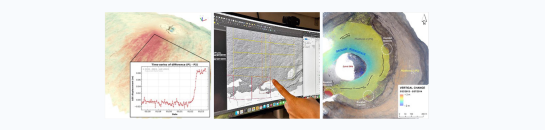
Satellite remote sensing
Images acquired by instruments onboard satellites are highly valuable to cover large areas of few to hundreds of square kilometres. They offer various ranges of spatial, temporal, and spectral resolutions, allowing to detect, map and measure geohazards at different scales. In CGIS, we mostly exploit multispectral and synthetic aperture radar (SAR) imagery to better constrain geohazards in space and time and measure their dynamics and evolution.
Photogrammetry
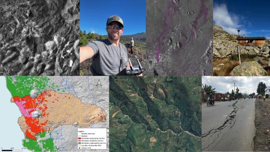
Photogrammetry is literally the art of measuring with photographs. Modern techniques of photogrammetry are used by CGIS to create high to very-high spatial resolution topographic information and orthoimages, which are, next, used for the study of land use land cover changes, topographic changes, and ground movements.
Photogrammetry is mostly exploited by CGIS with metre to sub-metre scale imagery coming from aerial surveys. The aerial imagery comes either from historical aerial surveys, providing a unique opportunity to study 40 to 70 years old landscapes, or from recent acquisitions performed with Unoccupied Aerial Vehicles (UAVs), a.k.a. drones.
Geodesy
Two main geodetic techniques are commonly applied by CGIS: GNSS positioning and SAR interferometry (InSAR). GNSS are mostly used for georeferencing purpose and, sometimes, for topographic surveys, while InSAR is used for the detection and study of ground deformation and ground surface changes associated with geohazards (i.e., DInSAR, DEM creation).
GIS
Finally, Geographic Information Systems (GIS) are used to perform geospatial analyses and mapping based on the different inputs coming from remote sensing, photogrammetry, and field surveys. GIS offer the possibility to go beyond the creation of geospatial data, through statistical and time-series analyses that help better understand the natural and anthropogenic processes influencing geohazards, at various scales.
What does CGIS do to study geohazards?
Through the collaboration with the Royal Museum for Central Africa, CGIS has focused most of its research activities on Africa, while also tackling comparable case studies elsewhere. This research strategy allows synergies with other researchers of the VUB, such as, the Physical Geography research group, and the BClimate research group.
More specifically, CGIS tries to develop appropriate remote sensing methods to understand the spatial and temporal distribution of geohazards, and the role played by urban expansion. CGIS works are three different levels: 1) the detection and mapping of geohazards, 2) the study of the processes controlling their occurrence, and 3) the assessment of their impacts in urban and rural environments.
Photos © Royal Museum for Central Africa / Vrije Universiteit Brussel